


The AI4DTE specific project supports the implementation of hybrid artificial intelligence models for Earth observation time series, in fusion with complementary, heterogeneous data and in situ or other hierarchically structured information sources, to offer an enhanced perspective for Earth monitoring and biophysical variables relevant for climate change.
BRIDGING THE GAP BETWEEN CLIMATE CHANGE UNDERSTANDING AND LOCAL ACTION
Although Earth's climate has changed naturally throughout history, the rapid warming observed today is overwhelmingly driven by human activities. Understanding, monitoring, and mitigating these changes require the integration of vast amounts of heterogeneous data originating from Earth observation (EO) satellites, in situ measurements, and digital sources. There are 2 key challenges:
- Big data analysis. Despite the unprecedented availability of environmental data, significant challenges remain. EO missions operate across different sensing modalities and temporal cycles, leading to spatial, temporal, and spectral gaps. At the same time, historical in-situ datasets and rapidly growing digital data sources are often fragmented and difficult to combine into a coherent representation of the Earth's state. This limits our ability to perform comprehensive assessments and generate actionable insights.
- Scale variation between climate modelling and adaptation. More, a critical mismatch exists between the scales at which climate processes are modeled and the scales at which adaptation actions must be implemented. Global climate models typically describe changes at spatial resolutions from 50 km to 150 km; regional models can decrease to around 10 km, whereas adaptation measures are required at the scale of human activities, from 10 m to 1 km. Bridging this gap is essential for supporting local decision-making and developing effective climate resilience strategies.
DATA AND METHODS
AI4DTE advances Digital Twin Earth (DTE) technologies to support climate change assessment through integrated monitoring, modeling, forecasting, and scenario analysis of environmental and human systems.
The focus is on the new paradigms of artificial intelligence (AI) addressing the entire value chain: data processing to extract information, information analysis to gather knowledge, and knowledge transformation into value. The AI4DTE science paradigm is grounded on the synergy of machine and deep learning methods selected to optimally solve the challenges of Big Data for the EO and complementary information:
- Data quantitative analytics
- Machine learning and deep neural networks
- Spatio-temporal data analysis and mining
- Model learning and physical parameter prediction
DTEClimate integrates a comprehensive modeling of local and time-localized events relevant for themes like freshwater lakes, biodiversity, extreme weather, and one health. AI4DTE supports the activity of these themes through custom methods based on satellite data processing, historical monitoring of biophysical variables, and artificial intelligence/deep learning methods.
CASE STUDIES - Examples:
1) Ecosystem evaluation variables for the Babadag Forest (BAIA Plot) using Sentinel-2 and GEDI data - Biodiversity theme
Given the environmental challenges posed by climate change, effectively managing biodiversity, biosafety, conservation, and ecological restoration requires the integration of Earth observation (EO) satellite data into assessment and monitoring processes. The vertical structure of forests is strongly correlated with aboveground biomass, productivity, and biodiversity. Therefore, accurate canopy height data is crucial for ecological research, particularly for biodiversity modeling and habitat quality assessment.
To estimate canopy height, we employ a probabilistic deep learning model that fuses GEDI data with Sentinel-2 imagery. The Canopy Height Model (CHM) utilizes an ensemble of convolutional neural networks (CNNs) to extract spectral and textural features from Sentinel-2 optical images, producing a high-resolution canopy height map. The model’s spatial and temporal resolution is further enhanced through sparse supervision using well-distributed reference observations from GEDI data.
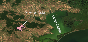
Our study focuses on the Baia forest lot within the Babadag Forest, Dobrogea. This area features a thermophilous deciduous forest, predominantly composed of Quercus petraea (sessile oak), with tree heights ranging from 10 to 40 meters.
A time series of 21 Sentinel-2 images - evenly capturing the phenological cycle of vegetation throughout 2020 - was used to create image-by-image canopy height maps that evaluate structural variations over time. Three of them are below:
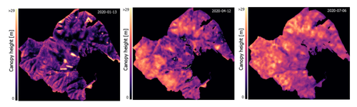
During the winter season, oaks shed their leaves, resulting in lower canopy heights. However, in areas with pine stands within the Baia plot, higher canopy heights are expected during winter due to their evergreen nature. In the summer season, oaks develop a dense canopy, leading to increased estimated heights.
2) Estimating the risk of Dengue fever around Razim-Sinoe using in-situ, climate and Sentinel-2 data - One Health theme
Climate change is expanding warm and humid environments that favor the proliferation of insect species previously confined mainly to tropical and subtropical regions. As a result, mosquito species that act as vectors for tropical arboviruses are increasingly establishing themselves in Europe, posing emerging risks to public health.
Among these, Aedes mosquitoes and the dengue virus are of particular concern. Rising temperatures and changing environmental conditions create more favorable habitats for mosquito survival and enhance conditions for virus replication and transmission.
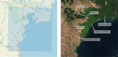
Climate projections for Romania suggest that rising temperatures could extend the period favorable for dengue virus transmission by up to two months. This study also targets the Danube Delta area, particularly the approximately 8,000 km² Razim–Sinoe lagoon region, selected for the presence of Aedes albopictus and its diverse landscapes, including forests, agricultural terrains and coastal ecosystems.
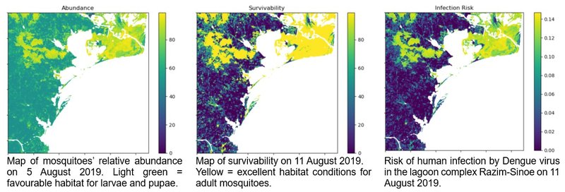
Input data include in situ measurements (air temperature and humidity at the 2m level) and three Sentinel-2-derived spectral indices characterizing vegetation health, water and soil moisture (3 reference images, acquired between 5 and 11 August 2019). The evaluation for the risk of Dengue fever emergence depends on the estimated abundance of the Aedes albopictus mosquito, its survivability as an adult and the virulence of the Dengue virus.
SOCIETAL IMPACT
By combining Earth observation, in-situ measurements, and advanced modelling, AI4DTE transforms them into actionable knowledge for climate adaptation, risk assessment, and environment management.
Solutions developed and proposed within AI4DTE address the following:
- Climate and Environmental Impact: Improve monitoring, modelling and assessment of environmental change, ecosystem dynamics, and climate-related hazards.
- Societal Impact: Support decision-making by providing accessible, data-driven insights for stakeholders, public authorities, and communities.
DELIVERABLES
D1-6.2. Dissemination and exploitation report
LIST OF PUBLICATIONS
A detailed list of publications is available in deliverable D1-6.2 Dissemination and exploitation report, available above.