

The REACTIVE project supports climate adaptation research by integrating Earth Observation data, environmental seismology, atmospheric monitoring, and citizen science observations to document extreme events in Romania.
REACTIVE DASHBOARD
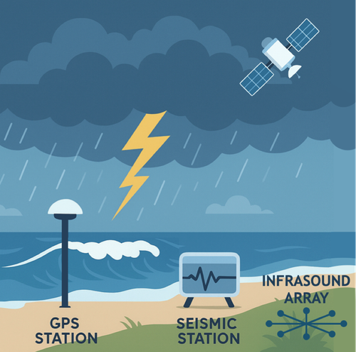
Developed by the National Institute for Earth Physics (INFP), the platform combines GNSS-based atmospheric measurements, seismic monitoring based on background analysis, infrasound observations, lightning detection networks, and Black Sea water level data to create a multi-hazard monitoring system.
EXTREME EVENTS AND CLIMATE CHANGE
Climate change is increasing the frequency and intensity of severe storms, heavy precipitation, floods, and coastal hazards in the Carpathian–Black Sea region. The REACTIVE project provides analyses, forecasts, and reports for assessing natural and anthropogenic events, quantifying uncertainties, and responding to hazard scenarios. It supports climate adaptation research and aligns with European initiatives such as the EU Climate Adaptation Strategy, Copernicus Earth Observation Programme, and the Horizon Europe climate missions.
DATA AND METHODS
By collecting real-time data from sensors placed in various locations, an interactive and intuitive map has been created to display detected events. By aggregating complex data into a simplified and unified format, the platform enables users and researchers to track and study these events more efficiently.
Collected data (satellite, in situ, sensors, laboratory experiments):
- Seismic: High-frequency (>30 Hz) signals for rainfall intensity; microseismic bands (0.1–1 Hz) for wave-induced ground motion; ambient seismic noise H/V ratios for seasonal site response; continuous ground vibration across Romania.
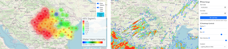
- GNSS: Precipitable water vapor tracking multi-day atmospheric moisture buildup.
- Infrasound: Acoustic signals detecting atmospheric pressure and electrical disturbances; lightning-related signals.
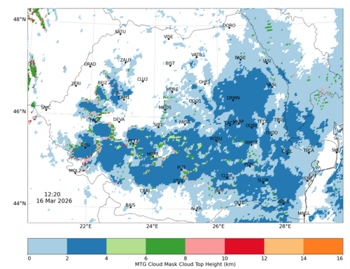
- Satellite: Geostationary lightning observations; ERA5 meteorological reanalysis.
- Modeling: Hydro-seismo-elastic simulations to predict rainfall-driven soil stiffness and ground motion changes.
Analytical workflows:
- Multi-sensor data fusion to reconstruct storm evolution (e.g., Black Sea Storm 2024)
- Seasonal H/V analysis combined with meteorological data to model soil-atmosphere interactions
- Predictive modeling of ground motion changes under varying hydrological conditions
- Unsupervised machine learning for infrasound event detection and signal classification
PLATFORM DESCRIPTION
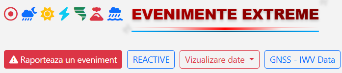
The REACTIVE online platform (infp.ro/dashboard-reactive | reactive.infp.ro/events) integrates multiple monitoring systems into a unified interface for real-time environmental observations. Components include a multi-hazard monitoring dashboard, data integration pipelines, a METEO Alerts warning module, citizen science reporting tools, and visualization services for atmospheric, seismic, and environmental datasets.
- Monitoring Systems: Modular multi-sensor observatories capturing seismic, GNSS, infrasound, and satellite signals.
- Visualization: Real-time dashboards, sensor data represented as separate data layers, time series display, and temporal filtering.
- Scalable Architecture: Modular design enabling addition of new sensors, regions, or analytical tools.
CASE STUDIES - Examples:

Black Sea Superstorm (August 2024)
- Location: Romania’s Black Sea coast; record-breaking rainfall and storm-driven waves
- News covering the event (example from ProTV): https://stirileprotv.ro/stiri/actualitate/litoralul-romanesc-devastat-de-furtunile-puternice-ztotul-e-rupt-curtile-oamenilor-e-calamitate-e-distrugere.html
- Observations & Findings:
- High-frequency seismic signals tracked rainfall; microseismic bands reflected wave-induced ground motion.
- Infrasound recordings detected 1,100+ lightning-related signals; acoustic patterns aligned with seismic activity.
- GNSS captured multi-day buildup of precipitable water vapor preceding peak rainfall.
- Satellite lightning and ERA5 data provided atmospheric context.
- Analysis: Integration of all datasets reconstructed storm dynamics; AI-based infrasound classification distinguished storm vs. background signals.
Seasonal Seismic Site Response (Romania)
- Location: Multiple seismic sites across Romania; seasonal hydrological effects
- Observations & Findings:
- H/V spectral ratios fluctuate seasonally, amplitudes respond to rainfall; resonance frequencies largely stable.
- Near-surface soil temperature lags surface cycles by up to a month.
- Subtle soil stiffness changes detectable via hydro-seismo-elastic modeling.
- Modeling: Seasonal soil–atmosphere interactions simulated using hydro-seismo-elastic programs; rainfall converted into predictive ground motion changes.
SOCIETAL IMPACT
The monitoring network supports the observation of atmosphere-hydrosphere-lithosphere interactions in seismic, infrasonic, geodetic, and atmospheric domains, as well as the characterization of extreme phenomena such as tsunamis, storms, and sea level rise.
- Early Warning & Decision-Making: Multi-sensor monitoring improves detection of extreme storms, floods, and coastal hazards; provides decision-support tools for authorities and emergency management.
- Resilience Building: Predictive models of soil behavior under rainfall aid infrastructure planning and risk assessment.
- Policy & Adaptation: Supports climate-aware hazard monitoring, guiding adaptation to increasing frequency of extreme weather.
- Research & Innovation: Demonstrates value of non-traditional datasets for holistic storm analysis and pan-European multi-sensor observatories.
The REACTIVE website (reactive.infp.ro) offers additional details on specific project objectives, implementation activities and results.