


The EO4NATURE project focuses on addressing environmental challenges caused by climate change, referring to ecosystem monitoring, biodiversity management, biosecurity, protection, and ecological restoration by integrating Earth observation data into monitoring and assessment processes.
EO4NATURE Website | EO4NATURE Dashboard
ECOSYSTEMS AND BIODIVERSITY UNDER CLIMATE CHANGE
The ecosystem assessment is essential in generating information on the state of ecosystems and ecosystem-derived services in order to support the sustainability of the environment, as well as local businesses. Ecosystem services are the direct and indirect benefits that ecosystems offer to human well-being and quality of life. Climate change impacts natural ecosystems and, consequently, the services they can provide to society.
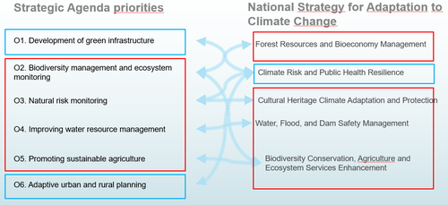
EO4NATURE promotes a strategic agenda aligned with key domains of the National Strategy for Climate Change Adaptation, as follows:
EO4NATURE aims to contribute to the following objectives:
- answering ecosystem monitoring needs by integrating Copernicus Sentinel and other satellite data for deriving useful information for ecosystem assessment (ecosystem condition, ecosystem services);
- addressing biodiversity management by recommending a set of indicators derived from satellite data to be used in the implementation of the Habitat directive (HD - 92/43/EEC), Birds directive (BD - 2009/147/EC), Water Framework directive (WFD - 2000/60/EC), Invasive Species Directive (ISD - 1143/2014) and management plans at Natura 2000 sites level;
- monitoring ecosystem services indicators for biosafety and protection and evaluating how satellite-derived parameters can help quantify normal evolution of the ecosystem from loss of biodiversity;
- proposing and measuring parameters that are relevant to ecosystem integrity and functionality and assessing how satellites can aid in the restoration of ecosystems;
- developing the methods that combine EO satellite and in-situ data to derive the specific parameters required to support the above-mentioned activities;
- assessing the impact of ecosystem services on circular economy, bio-industries, and local bio-economy applications to increase sustainability of local businesses
DATA AND METHODS
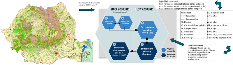
Romanian ecosystems are classified based on European Nature Information System habitat (EUNIS) level 3 (L3) codes (most recent version, 2022/2021), while available services follow the Common International Classification of Ecosystem Services (CICES). For the evaluation, a set of structural and functional indicators that can reflect the negative impact of climate change on the characteristics of these ecosystems is proposed. Indicators that can be derived from multispectral and radar satellite images are chosen (e.g., NDVI - Normalized Difference Vegetation Index, NDWI), having the advantages of spatial coverage at a national scale and sufficient temporal resolution to reflect changes.
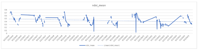
This study uses Copernicus Sentinel data (available in open access) to derive useful information for ecosystem assessment (ecosystem condition and ecosystem services). An example of a multiannual (2016-2023) timeseries of the mean NDVI for a selected pasture area in the Măcin Mountains is exemplified hereafter:
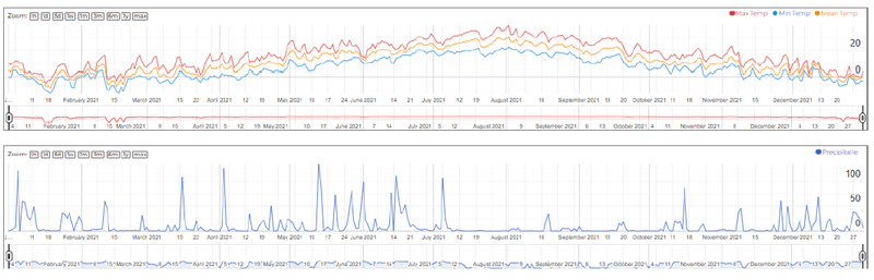
Moreover, several climate-relevant variables are included (e.g., minimum/maximum/mean temperature and precipitation) in the analysis. For the same pasture area, the temperature and precipitation timeseries for 2021 is shown below:
For a selected time-bound period and applying fuzzy logic reasoning on input climate and EO indicator values, the output consists of fuzzy risk/opportunity scores. The evaluation also follows E (Environment) - S (Social) - G (Governance)-based rules, as these dimensions are directly linked to ecosystem services, biodiversity status, and socio-ecological resilience.
CASE STUDIES:
The project focuses on five case study locations (one for each biogeographical region in Romania: alpine, continental, steppe, Pannonian, and sea or coastal).
Măcin Mountains Example
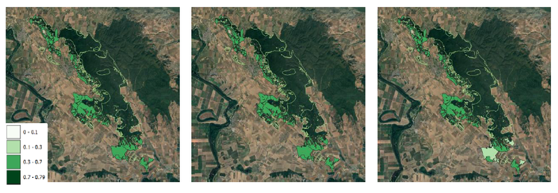
The Măcin Mountains Natura 2000 site is used as the main case study to assess spatial variability of vegetation conditions within the steppe biogeographical region. Thresholded seasonal NDVI maps form the basis for indicator evaluation in such grassland ecosystems.
The mean NDVI seasonal analysis is performed for three main intervals (S1—May to June, S2—July to September, and S3—October), allowing the identification of changes during different stages of the vegetation cycle. The example below is available for 2023.
SOCIETAL IMPACT
Remote sensing–based indicators of ecosystem condition provide valuable tools for environmental agencies and local communities, enabling timely assessments of ecosystem health and services while supporting the implementation, monitoring and enforcement of conservation policies.
DELIVERABLES
- D3-1.1 Framework for assessing ecological condition
- D3-1.3 Indicator set for assessing ecological condition
- D3-1.4 Indicator set for assessing ecosystem service potential
- D3-2.4 Bio-industry and bio-economy applications for ESG benefits report
- D3-5.3 Seminar report
- D3-5.4 Conference report
LIST OF PUBLICATIONS
Explore more details about the specific project's activities on: https://dteclimate.rosa.ro/